Road conditions maps, good and bad
I had occasion Saturday afternoon to travel to Joplin with my dad (a seasonal celebrity), who was making an appearance at the Sam's Club there. There was freezing rain in the forecast, so I spent some time before leaving town looking for current weather and road condition information.
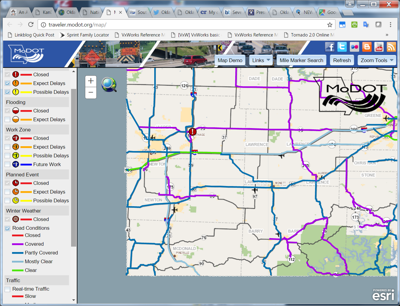
Getting current information about Missouri road conditions was easy. That link leads to an interactive map showing you whether a segment of road is clear, mostly clear, partly covered with ice/snow, covered, or closed. Icons show construction closures and major wrecks, which can be clicked to show more information. For example, within a few minutes of a semi-trailer wreck at mile 49 of I-44, east of Mount Vernon, Mo., the map showed an icon indicating that the wreck occurred at 5:30 pm, that the right lane was blocked, and that it would be about 2 hours before both lanes were reopened to traffic.

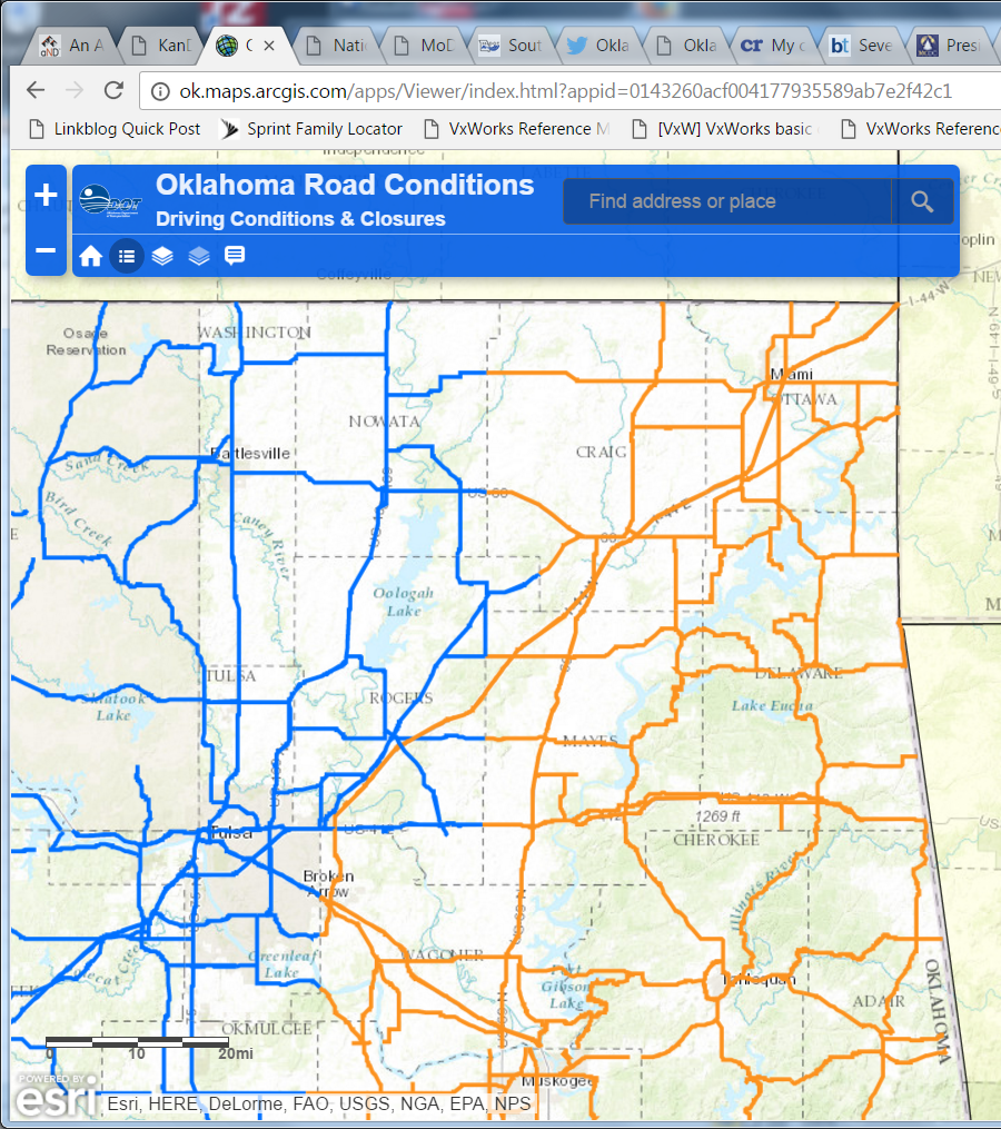
The Oklahoma road conditions map, by contrast, assigned three conditions to the roads -- moderate, severe, closed -- and the same condition was applied to all the roads in a county (with the exception of turnpikes). While Missouri drew a distinction between roads which were known to be clear and roads for which the condition was unknown, Oklahoma's map showed both as unhighlighted. Clicking on the Oklahoma map produced the same boilerplate text for the condition shown -- no location-specific information.

Another thing I did to prepare for the trip was to be sure I was subscribed to Twitter feeds for the Oklahoma Turnpike Authority, Oklahoma Department of Transportation, Missouri Department of Transportation - Southwest, and National Weather Service offices in Tulsa and Springfield, and to turn on mobile notifications -- sending any new tweets to my phone. I had hoped that these agencies would use social media to provide up-to-the-minute news on road conditions and closures. Not so much.
As we drove northeast on the Will Rogers Turnpike, we started to encounter freezing drizzle around the Foyil exit. We had to stop at midway to clear the ice around the edges of the windshield and on the wipers. As we got closer to Big Cabin, we drove past a couple of jack-knifed trucks off the side of the road-- they evidently hit patches of ice on the bridges. (Thanks to the warm temperatures a day earlier, the ice was melting when it hit the road surface -- except on the bridges.) Past the Afton exit, traffic came to a stop.
Ten minutes later, it began moving again, but we soon learned that the Highway Patrol was directing all traffic off of the turnpike. A patrol car blocked the eastbound lanes, and Miami police cruisers were keeping traffic from entering the turnpike in either direction. We rerouted via OK-10 and MO-43, which added about 30 minutes to the trip but had very little traffic.
When did the OTA take to Twitter to notify motorists that the turnpike was closed? Over an hour later, at 4:39 pm. The OTA telephone hotline (1-877-403-7623), supposed to have to have the latest information about turnpike conditions, had not been updated since Friday morning, according to a tweet at 3:28 pm Saturday. It was updated at 5:30 to report that eastbound Will Rogers Turnpike was closed but one lane was open westbound.
Meanwhile, on Twitter, OTA reported at 5:09: "WILL ROGERS TURNPIKE HAS ONE LANE WESTBOUND OPEN AT THIS TIME. EASTBOUND STILL CLOSED."
At 6:00 pm: "WILL ROGERS TURNPIKE EB REMAINS CLOSED DUE TO ICE AND ACCIDENTS. TURNER TURNPIKE IS OPEN IN ALL DIRECTIONS." My question in reply at 6:03 pm -- "What is the plan for salting and sanding Will Rogers Turnpike?" -- went unanswered.
There were no further updates from OTA until they replied to my 8:38 pm tweet noting the lack of hotline updates. Even then, it took another question from me to elicit the information that the closure was only from the Miami exit eastward.
It's a big deal for an interstate highway on a major cross-continent route to be shut down for hours. Twitter, the web, even telephone hotlines offer a quick and inexpensive way to communicate information and keep it current, but only if officials make it their job to provide precise and frequent updates and to respond promptly to questions.
A closing question: How is it that it was safer to drive on the taxpayer-funded side roads than the user-funded toll roads? Shouldn't some of those big toll dollars have gone into salting the turnpike, preventing accidents, and keeping the road open?
ONE MORE THING: OKDOT's 8 p.m. Saturday news release neglects to mention that the Will Rogers Turnpike is closed east of Miami. Did they not know, or did OKDOT not mention it since the turnpike is OTA's responsibility and not OKDOT's? Do they expect travelers to know that there are two different agencies overseeing road conditions?

0 TrackBacks
Listed below are links to blogs that reference this entry: Road conditions maps, good and bad.
TrackBack URL for this entry: https://www.batesline.com/cgi-bin/mt/mt-tb.cgi/7917