Oklahoma railroad system maps, past and present
 Too tired tonight to do much more than link. I've been working on a post about the Oklahoma City Union Station rail yard / I-40 relocation controversy, but it's not ready. For now, here are links to some maps and other information about the history of the state's rail network, from most recent to oldest:
From the Oklahoma Department of Transportation's website. (Note how much of the network is owned by ODOT and leased to various railroads, including the entire Frisco route from Tulsa to Oklahoma City.)
- Oklahoma 2009 railroad map
- Oklahoma 2009 railroad map - reverse showing city detail
- Oklahoma Centennial 2007 railroad map
University of Alabama collection of historical Oklahoma maps. The browser is annoying, and you can't download high res copies, but there's some very interesting material here, including:
- A 1921 Rand McNally state map with railroads and interurbans, with more interurban station names
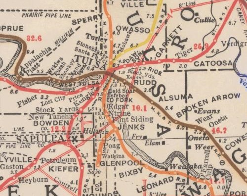
- 1917 Corporation Commission map of railroads and pipelines: The Tulsa County section is shown above
Note the interurbans connecting Bartlesville to Dewey, Nowata to Coffeyville, Oklahoma City to Norman, El Reno, and Guthrie, Lawton to Ft. Sill, McAlester to Hartshorne, Shawnee to Tecumseh, and Miami to the rest of the Tristate mining region. As far as I can tell, only Tulsa's interurban lines -- Sand Springs and Tulsa-Sapulpa Union (originally the Oklahoma Union Traction Ry.) -- remain in operation, as freight-only short lines.
OkGenWeb's 1915 state map with a list of railroad names and abbreviations -- high res scan
Doug Loudenback's high res scan of a 1905 map and gazetteer of the Twin Territories, with Doug's observations. The original: 1905 Premier series map of Oklahoma and Indian Territory (Library of Congress)
UPDATED 2023/12/29 to fix broken links to the University of Alabama map archive and to update the okgenweb.org link to point to okgenweb.net
0 TrackBacks
Listed below are links to blogs that reference this entry: Oklahoma railroad system maps, past and present.
TrackBack URL for this entry: https://www.batesline.com/cgi-bin/mt/mt-tb.cgi/4996
Was Rudd on the Katy Railroad near Harvard Avenue where a spur connected to the fairgrounds? Was Rudd a small community?
Based on some other maps, I'm inclined to think it was closer to Yale. There was at least one other spur just west of Yale, connecting to a lumber yard on the north side of the expressway. (There was a traffic light to stop cars on the BA when the spur was in use.) I've never heard of a community called Rudd. That would also have been an active coal mining area at the time, so Rudd may be the name of a mining company.
I'd never heard of Rudd, either.
I think Reid Spur was near to what is currently the northeast corner of 31st and Yale. "RUDD" appears in larger lettering between Reid Spur and Kendall, so I was guessing that Rudd might have been associated with another spur which ran along the west branch of Joe Creek from the main Katy line just east of Harvard toward 21st and Pittsburg.
My gggrandparents were killed in a train wreck in Oklahoma Nov 21, 1941. I cannot find any information about this accident. I think it was in the Stillwater area. Does anyone know what rail line this might have been?
Carol,
Stillwater Oklahoma is located on what was formerly the Eastern Oklahoma Railway a subsidary of the Atchison,Topeka & Santa Fe Railway. This branch was sold by the Santa Fe in 1998 to the Stillwater Central Railroad a subsidary of the Watco Companies. Stillwater News Press is the local newspaper. Hope this helps.
My grandfather listed his home address on his 1917 draft registration as Bisbee, OK. I found a site which listed Bisbee as a place on a rail line, maybe the C,O, & G. Does anyone know where this was? They tended to live in the OKC to Shawnee area.
In approx. ~1870-1875 my great grandfather is believed to have owned stables of mules leased out to work on(construct)an OK railroad near the Red River. If this makes sense to anyone I'd like to fit the pieces of history together.
End
That was the period in which the Missouri, Kansas, & Texas Railroad was building the first railroad across Indian Territory, starting on the Kansas border and building toward Texas, following the Texas Road. US 69 parallels the line through most of its length in Oklahoma. Near the Red River it passes through Durant, Oklahoma, and Denison, Texas.
I'm curious about the history of railway development around Owasso. I'm doing a research project for a site on East 76th Street North, and it appears as if it is bordered by a segment of the Atchison, Topeka and Santa Fe Railway, though it is tough to tell how long that railway has been there just by looking at old topographic maps and aerial photos. I know from my readings that in 1897, the Kansas, Oklahoma Central & Southwestern Railway Company acquired right-of-way approximately three miles northwest of the Elm Creek Settlement, which I think could potentially be my site. And additional information you might have would be appreciated.