Shipping Forecast centenary
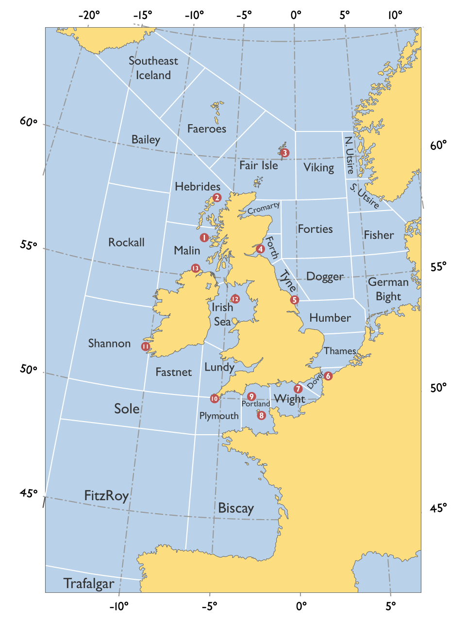
We are in between two 100th anniversaries of the Shipping Forecast on radio. The summary of maritime weather for sea areas near the British Isles was first broadcast on the radio on January 1, 1924. It was first broadcast on the British Broadcasting Corporation in October 1925. The forecast itself dates back to 1861, developed by Vice-Admiral Robert FitzRoy and originally delivered via telegraph to coastal stations.
Beyond its utility to ships at sea, the Shipping Forecast is beloved for its soothing effect. It is read by a BBC continuity announcer at a steady pace and tone, with the names of sea areas and terse forecast terminology read at a hypnotic rhythm. The forecast is preceded by the playing of "Sailing By," a waltz by light orchestral composer Ronald Binge; the music is meant as an aid to tuning in advance of the forecast, but the sweet strings and flutes enhance the calming effect. I encountered the broadcast on my first visit to the UK in 1989, when I listened to Radio 4 throughout the day.

In the early days of BatesLine, in December 2003, I posted a self-indulgent reminiscence about a novelty song I had heard once on Doctor Demento, the Shipping Forecast set to Anglican chant, by a group of school teachers who called themselves the Mastersingers. (The reminiscence was inspired by a Daily Telegraph column by future London Mayor and Prime Minister Boris Johnson.)
That post served as a beacon, and it attracted emails and comments from people connected with the group, including Helen Keating, the wife of Geoff Keating, a member of the group. It's an interesting story with connections to Beatles producer George Martin and comedic actor Peter Sellers. I compiled that authoritative information into the definitive story of the Mastersingers, the Weather Forecast, and the Highway Code, published in May 2007. I note with some pride that it is the chief source cited by the Wikipedia article on the Master Singers. (The name of the group appears on the records with a space, but I follow Helen Keating's practice of treating Mastersingers as one word.)
BBC Sounds has a collection of programs in honor of the Shipping Forecast centenary. Be aware that many of these programs will be available online only until the end of January 2025:
- My Shipping Forecast: Leading fans of radio explain what the Shipping Forecast means to them.
- The Shipping Forecast: A Beginner's Guide: Paddy O'Connell guides us through the history and meaning of 'The Ships'.
- Sailing By: Soul Music: Stories about a piece of light music which became interwoven with the Shipping Forecast.
- Solomon Browne: Forty years on, the dramatic story of the Penlee lifeboat disaster.
- The Shipping Forecast: A Haven Illuminated: Discovering who really listens to the Shipping Forecast at 00:48 every day.
- The Shipping Forecast: Poetry Please: Roger McGough is joined by Paul Farley, sharing poems inspired by the Shipping Forecast.
- Archive on 4: The Shipping Forecast: Shipshaped: Jerry Brotton explores how Britain's maritime heritage has shaped us.
- Sea Like a Mirror: An atmospheric gathering storm of a documentary explores our language for naming the wind.
- Seaborne by Nuala O'Connor: Irish author Nuala O'Connor's sixth novel is a rollicking portrayal of the life of 18th-century pirate Anne Bonny. (Ten 15-minuted episodes.)
- The Shipping Postcards: Visits to the areas from the Shipping Forecast: Lundy, Dogger, Forth, Irish Sea, Wight. (Two hour-long episodes.)
- Front Row on the Shipping Forecast, at the Cutty Sark: Samira Ahmed with a special edition of the arts programme exploring the Shipping Forecast.
This archived Met Office article has the history of the Shipping Forecast and changes to the sea area definitions over the years.
"The Shipping Forecast - an icon of British weather and safety at sea" is the slide deck for a 2018 presentatio by Jim Galvin of the Met Office, Exeter, explaining the history and terminology of the forecast, and the importance of forecasters in the unique conditions around the British Isles. One slide shows the cones and cylinders that would be hoisted at coastal observation stations to indicate approaching gales and high winds, used before radio communications were available. The presentation explains the Beaufort wind scale, sea states (wave heights), and the meanings of the terse terms used to stay within the 380-word limit.
MORE:
Jo Ellison writing in the Financial Times:
It's always seemed one of the more yawning ironies that a nightly radio dispatch designed to protect sailors from the most treacherous stretches of water should have been co-opted by half of its audience as being the equivalent of aural Xanax.
BBC continuity announcer Viji Alles (whose radio voice I envy) offers the #ShippingForecastChallenge -- try your hand at making a recording.
As an aid to sleep, here is five whole hours of the Shipping Forecast.
Peter Jefferson, who read the Shipping Forecast from 1969-2009, now has a version featuring unusually calm conditions for the Calm app.
Recently, the Royal Museums Greenwich posted a sea areas map from 1956, placing the sea areas listed in the broadcast Shipping Forecast in the larger context of the northeastern Atlantic Ocean. FAREWELL is a rather ominous name. I wonder if MILNE is meant to honor the author of Winnie The Pooh. (The map can be found here as well.)
France has its own set of sea area names, like Romeo, Altair, and Faraday. It has a Finisterre which overlaps with but is smaller than the British area formerly known as Finisterre, changed in 2002 to Fitzroy. The US has sea areas too, but they aren't geographical or poetic at all -- three letters followed by three digits.
0 TrackBacks
Listed below are links to blogs that reference this entry: Shipping Forecast centenary.
TrackBack URL for this entry: https://www.batesline.com/cgi-bin/mt/mt-tb.cgi/9299