Maps: January 2019 Archives
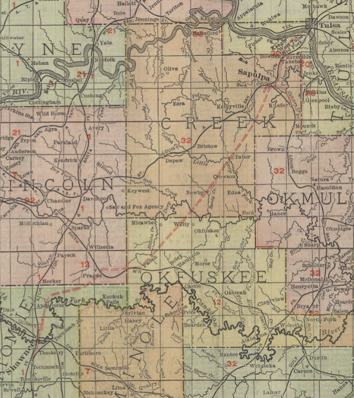
Another interesting map find. This Rand McNally Vest Pocket Map of Oklahoma from 1910 appears to be an earlier map, overprinted in red to show numbers indexed to railway names and parcel companies and to show electric railway lines.
The U. S. Post Office did not deliver parcels until January 1, 1913. Prior to that date, the parcel delivery business was handled by a cartel of companies. The index to this map lists four: Wells Fargo & Co.'s Express, American Express, Pacific Express, and United States Express. Each railroad was tied with a specific express company -- Santa Fe and Wells Fargo, Frisco and United States Express, Katy and American Express, etc. Presumably, you'd need to know which town was served by which express company in order to send a parcel. This U. S. Postal Service history commemorating 100 years of parcel post explains that the lack of competition that brought demands for the government to enter the market.
The map of electric rail lines shows interurban lines linking Tulsa, Sapulpa, and Kiefer (now the de-electrified Tulsa Sapulpa Union Railway); McAlester, Krebs, Haileyville, and Hartshorne (the Choctaw Railway and Lighting Co.); Shawnee and Tecumseh; Capitol Hill (south Oklahoma City), Oklahoma City, and Edmond, with a broken line indicating expansion plans to Guthrie.
Linking the Shawnee and Sapulpa interurbans is a broken double line indicating a proposed electric railway connection passing through Prague in Lincoln County, Paden in Okfuskee County, Newby and Tabor in Creek County. Lest that seem like too long a route for trains running on overhead wires, the Sacramento Northern Railroad, an electric interurban line, connected Chico, Sacramento, and Oakland, 183 miles from end to end.

Sapulpa to Shawnee is one of many long-distance interurban proposals that never came to fruition. The December 16, 1910, edition of the Canadian Valley News, published in the town of Jones in Oklahoma County, reported that work had begun on the Tulsa to Sapulpa interurban line. "This is the line that will build on west to Oklahoma City, passing through Jones." The November 10, 1911, edition of the same paper reports an expected consolidation of the Tulsa-Okmulgee and Sapulpa interurban lines. I had never heard that Okmulgee had any sort of electric railway, much less a connection to Tulsa.
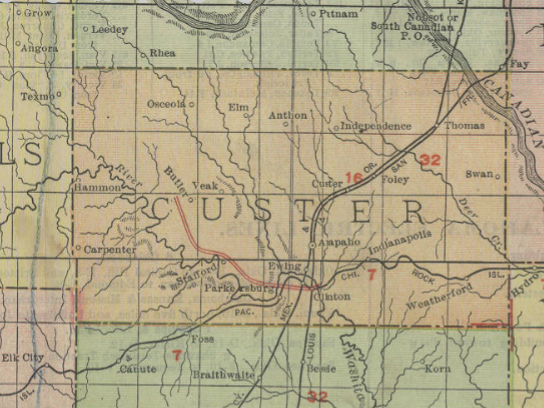
Another surprise on the map is an electric railway line beginning at Clinton, then extending west and north about 20 miles, into an area that lacks other railways.

This may be all that was completed of a proposal reported in the July 28, 1906, Trade Bulletin:
A WESTERN OKLAHOMA INTERURBAN.The Clinton, Cheyenne & Canadian Interurban Railway Co. is the name of a new company, recently organized at Cheyenne and incorporated with a capital stock of $1,000,000. The officers and directors are C. G. Gilkerson, president; L. L. Collins, vice president; R. V. Converse, secretary-treasurer; L. W. Pate and W. T. Bowers, all of Cheyenne. The proposed road will be built from Clinton, Custer county, to Cheyenne, Roger Mills county, and then to Canadian. texas. A branch line will be constructed from Cheyenne to Mangum. The projected road will open up entirely new country not now reached by any steam or electric line and should it be successfully pushed to completion, will be of great value to the farmers and merchants of this section and also a profitable investment for the stockholders.
The same page mentions plans from an electric interurban line from Ardmore to Lawton, one from Newkirk to Oklahoma City via Peckham, Blackwell, Tonkawa, Billings, Perry, Guthrie, and Edmond; and Muskogee as the "center of a great interurban electric system."
Subsequent maps don't show proposed routes, except that the 1911 Rand McNally map of Oklahoma and 1912 Rand McNally map of Oklahoma have a dotted line from Sapulpa to Tulsa.
The 1913 Rand McNally map deletes the Clinton electric line and shows instead a steam railway on that route, the Clinton, Oklahoma, and Western, from Clinton to Strong City in Roger Mills County, via Butler and Hammon. Later maps show it continuing on to Cheyenne and the state line. The Oklahoma City interurban connects north to Edmond, south to Moore, and west to El Reno. The Sapulpa system has a branch to Kiefer and another south-southwest of town. There is a Muskogee-Fort Gibson line, a Bartlesville-Dewey line, a line from Miami north to Hattenville (Geneva post office), and the aforementioned McAlester-Hartshorne and Shawnee-Tecumseh lines. The 1913 map also shows the transfer of a six-mile-wide band of southern Kiowa County to Tillman County and 45 square miles from Wagoner to Tulsa County.
The 1928 Rand McNally map of Oklahoma may show the peak of electric rail in the state. Sapulpa to Tulsa interurban is complete, and the Kiefer branch has been extended to Mounds. The Sand Springs Railway is listed as a steam and electric railroad. The Oklahoma City system now reaches Guthrie and Norman. Muskogee has a second branch to East Muskogee. There are new lines connecting Nowata and Coffeyville in the northeast and Lawton and Ft. Sill in the southeast. The McAlester to Hartshorne line still exists, but the Bartlesville and Shawnee interurbans are gone.
MORE: Oklahoma rail historian Cecil Cloud writes that the Shawnee-Sapulpa proposal "may have been part of a much more comprehensive scheme that was being floated at that time":
Those were the peak years of the interurban mania, and paper roads were being promoted across the state. One that was being boomed in Sapulpa would have connected almost every major town in Northeastern Oklahoma, but it was never completed.Tabor was just north of what would become Slick and northwest of Beggs.. Paden to Newby to Tabor to Sapulpa would have made a connection from the Fort Smith and Western at Paden to the Frisco at Sapulpa. It would also have to cross both the Deep Fork and Little Deep Fork, as well as some rugged terrain southwest of Sapulpa.
The Oklahoma and Southwestern Railway, as well as the town of Slick,did not come into being until after 1920, but the proposed line would have crossed the O&SW slightly north of the Slick depot.
During the interurban era, the O&SW was advanced, along with the Midland Valley, as a potential merger partner for the Sapulpa and Interurban. Local and regional sources indicate that the Sapulpa and Interurban line south of Kiefer was taken up to build the line to Tulsa. Some grading may have been completed southwest of Mounds, in the direction of the proposed junction with the O&SW at Tolon. According to an old Frisco timetable, Tolon was between Edna and Nuyaka. There is a 1920s vintage OCC map in the town museum at Davis which shows a proposed extension of the Sapulpa and Interurban south from Mounds and almost to Okmulgee--but this was never built. The same map shows the Midland Valley branch from Jenks, through Perryman and Watkins, though Glenpool and on to a junction with the Sapulpa and Interurban at Kiefer.
I have a digital copy of the 1908 Rand Oklahoma Map, and this line does not show on it, nor does it show on the OCC 1909 Railroads of Oklahoma map. My 1908 map was also overstamped with the names of express companies and their associated railroads, as this was before the merger which created the Railway Express Agency.
The 1910s mania for interurbans, with new plans announced before any attempt to assess the geographical or financial feasibility of the proposals, brings to mind the airline mania of the 1990s, when airline boosters convinced city and state governments to subsidize new airlines with the promise of non-stop flights to the coast, which never materialized.