Oklahoma History: January 2010 Archives

Via the Google Earth Library blog, I found a collection of historic navigational charts for air and sea travel on the website of the National Oceanic and Atmospheric Administration. It's the Historical Map and Chart Project of the Office of Coast Survey. You can search the collection by state, date, type of map, or keyword. Here are a few that may interest you:
Civil Airways and Mileage, 1948
This map shows major airports and the designations for airways connecting them. With a few exceptions the US three-letter airport codes were then as they are today -- e.g., INK for Wink, Texas -- although the Canadian two-letter codes later had a Y prefixed to them.
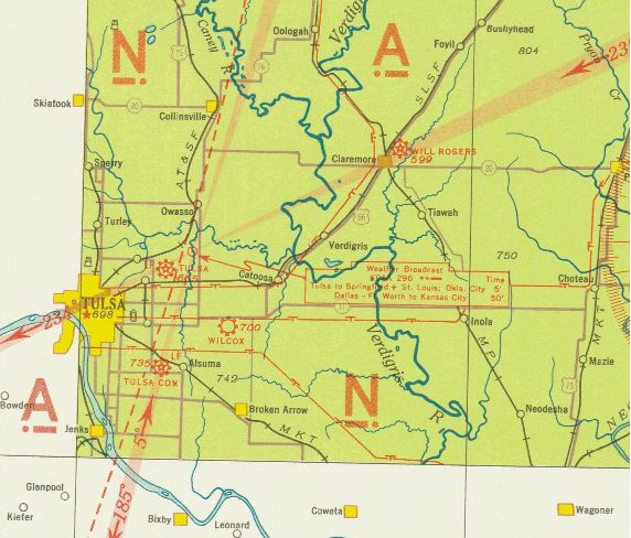
Tulsa section of United States Airway Map, 1934
Wichita section of United States Airway Map, 1933
These maps show airports, navigational aids, and land features visible from the air -- tank farms, highways, railroads, electric transmission lines, and bodies of water. The two maps together show the areas west, north, and east of Tulsa in the early '30s.
The Tulsa map shows the old alignment of US 66 through Tulsa, which jogged north from 11th St. to Admiral Pl. on Garnett (or so it would seem on this map. The fairgrounds race track is depicted. Note that what is now US 69 through Welch, Vinita, Pryor, and Chouteau used to be called US 73. Notice too that roads that these days travel diagonal paths used to jog back and forth on section line roads. The map shows Tulsa's main airport on N. Sheridan, Tulsa Commercial Airport at 51st and Sheridan, and Wilcox Airport, which may be the predecessor of Harvey Young Airport.
The roads depicted nearest Tulsa are a bit puzzling and don't seem to be to scale, but it looks like Peoria, Lewis, and Harvard extending to the south. It appears to show 96th St. going from the Jenks bridge to Mingo Rd., but perhaps that's meant to be 101st.
The Wichita chart shows Tulsa and the areas north and west. That road extending east of Jenks is labeled US 64 -- probably an error, but perhaps not. Look west of Sand Springs to see the now-inundated town of Keystone and the path of US 64 before Keystone Lake and Dam.
Up in Osage County, there's a substantial-looking place named DeNoya. The town, informally known as Whizbang (a name deemed too undignified to grace a post office), is now a pasture. When I was last there, in 1988, nothing remained but the footings of a few buildings.
The red stars on the map mark flashing or rotating beacons that marked the path of airways for nighttime navigation.
Oklahoma City sectional chart, 1950
This more recent map covers a smaller area than the 1930s sectional charts. It's interesting to see how small (relatively speaking) and fragmented Oklahoma City was, before the massive annexation about a decade later.