Tulsa Election 2024: September 2024 Archives
This Saturday, September 21, 2024, at noon, I will be a guest on Tulsa Beacon Weekend, hosted by Jeff Brucculeri. The hour-long interview program is heard in Tulsa on KCFO AM 970, live-streamed online here and on the KCFO app. The show is a production of the Tulsa Beacon, the weekly newspaper founded in 2001 by the late Charley Biggs.
My interview is the second half of the program. Jeff and I discussed the recent City of Tulsa election and Oklahoma primary, the mayoral recount and November runoff, and my recent entry about Tulsa municipal boundaries and fence lines.
The most recent episode is available to listen again for one week through the KCFO app and through the website: From the Listen Live popup, choose Menu, then the microphone icon, then choose Tulsa Beacon Weekend; Joe Riddle's Old Time Radio Theater is also available.
UPDATE: Here's a direct link to the audio file, which will be available through Friday, September 27. The first half of the program is an interview with former HGTV host David Benham, co-author with his brother Jason Benham of Miracle in Shreveport.
Since the City of Tulsa primary on August 27, I've received some questions from puzzled readers about city limits and jurisdictions.
One reader wanted to know why there were four Rogers County precincts listed in the City of Tulsa election results, but no votes were cast.
A friend who lives in Turley was ready to vote in the mayoral election, but his precinct didn't open at all on August 27. He has Tulsa water, a Tulsa address, and pays property taxes to Tulsa Public Schools, Tulsa County, Tulsa City-County Library, Tulsa City-County Health Department, and Tulsa Community College. He asks: Who takes care of Turley?
Another reader wanted to know how Vanessa Hall-Harper and Angela K. Chambers could run for Tulsa City Council District 1 when both are registered to vote in Osage County.
The big-picture answer is that, in Oklahoma, county boundaries, municipal boundaries, school district boundaries are completely independent of one another. Boundaries of state house, state senate, and congressional districts also are independent of any other political subdivision.
This is strange and confusing if you've come from some other part of the country or world. In Massachusetts, every square inch of territory is within a city or town, and there is no such thing as unincorporated land. By default, every municipality runs its own school system, but smaller municipalities can band together to form regional school districts for all grades or for secondary grades. Regardless, everyone who lives in a given municipality is part of the same public school system. Every Massachusetts municipality is entirely within one of the Commonwealth's 14 counties. When the City of Boston annexed the towns of Roxbury, West Roxbury, and Dorchester in the late 19th century, those areas changed counties, too, leaving Norfolk County for Suffolk County, and isolating Brookline as a no-longer-contiguous part of Norfolk County.
In Minnesota, there are exactly twice as many state representatives as state senators, and each state senate district is divided into exactly two state house districts. Senate District 1 is comprised of House District 1A and House District 1B. Outside of the metro areas, legislative district boundaries follow township and town boundaries. But school district boundaries are independent of township and town boundaries.
Plenty of Tulsans live in the Jenks, Bixby, or Union school districts. The fastest growing part of east Tulsa is the area within the Broken Arrow school district, southeast of 31st Street and 145th East Avenue. Only Berryhill, Union, and Glenpool school districts lie entirely inside Tulsa County -- every other school district has at least some territory in at least one other county. Although school districts typically share a name with their city or town, they don't share boundaries or governing bodies. Union and Berryhill don't even have a corresponding municipality, although Berryhill may change that.
Oklahoma school districts don't even have to be contiguous: Cherokee County is a crazy-quilt. Tahlequah has two major non-contiguous sections, plus small exclaves locally situate in three rural districts -- presumably individual farms that preferred Tahlequah schools to the local offering. Grandview and Peggs districts each have exclaves that are enclaves to the other. Closer to home, Sand Springs has two separate sections, one in Tulsa County and one in Osage County, separated by Anderson, an Osage County K-8 district that sends its students to Charles Page High School.
According to the Tulsa County Treasurer's website, there are 46 possible combinations of school district and municipality (or no municipality) in the county, each with a unique property tax rate. City of Bixby property owners in the Bixby school district are hardest hit, at 139.90 mills, while property owners in the Keystone school district pay only 92.10 mills, whether they live in the City of Mannford or in an unincorporated area. Bixby has the highest municipal property tax rate by far at 21.83 mills, while five municipalities (Collinsville, Glenpool, Owasso, Skiatook, Sperry) have no property tax at all because they have no general obligation bonds. The City of Tulsa overlaps with Tulsa, Union, Jenks, Bixby, Broken Arrow, Owasso, Berryhill, and Catoosa school districts.
Adding to the confusion: A municipality can annex skinny strips of land known as fence lines to protect unincorporated territory for future expansion by itself and against it being grabbed by a rival city. In the meantime, the city doesn't have to provide services to the surrounded land and the property owners aren't subject to city ordinances or taxes. Tulsa has a fence line that encompasses land between Red Fork and the Gilcrease Turnpike, some land in Osage County, Turley, the Cherokee Industrial Park, a corridor around US 75 south of 126th Street North, and the Tulsa Port of Catoosa. State law allows a city to annex any land it surrounds on three sides or more without the consent of the landowners.
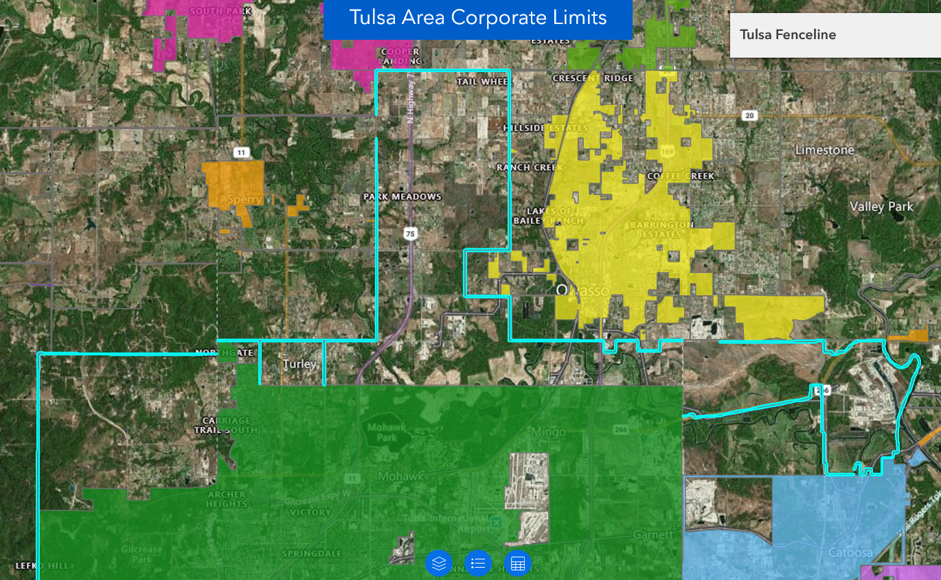 Screenshot from INCOG Tulsa area municipal boundaries interactive map showing Tulsa's northern fence line, outlined in cyan, adopted in 1973 with some adjustments since. The fence line is continuous; the visible discontinuities are an artifact of the map rendering software.
When our family moved to the Tulsa area in 1969, we bought a house in Rolling Hills, a geographically confusing place where we had a Tulsa address, paid the City of Tulsa for water, went to Catoosa schools, had a Catoosa phone number, but we were (at that time) in unincorporated Wagoner County. We had no police protection, the sheriff was an hour's drive away, there was a volunteer fire department, and roads were "maintained" by our Wagoner County Commissioner. There were a couple of failed annexation attempts in the 1970s. We moved a mile west into the City of Tulsa in 1978. Rolling Hills was annexed by Catoosa in 1997. (An extended reminiscence about Rolling Hills when it was "No Man's Land" will appear in a separate article.)
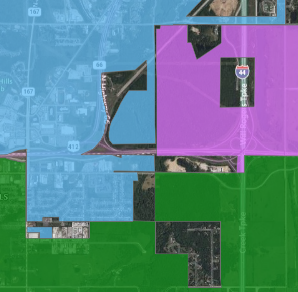 Screenshot from INCOG Tulsa area municipal boundaries interactive map showing the junction of I-44, US 412, and OK 66. Tulsa is green, Catoosa is blue, Fair Oaks is purple. Rolling Hills is the southernmost blue area, surrounded by green to the west, south, and east.
All that to say, I appreciate the confusion that people may feel. To address the specific situations my readers raised:
District 1 and Osage County: The City of Tulsa was entirely located in Tulsa County until 1959, when the city annexed several near-downtown subdivisions in Osage County, along with the Tulsa Country Club. A new master-planned community, Gilcrease Hills, opened in 1971. Tulsa annexed a fence-line around the development in 1973, protecting Gilcrease Hills against annexation by Sand Springs, and then annexed the development itself in 1978. Both the incumbent and the challenger for the District 1 Council seat live in Gilcrease Hills. From 1973-1991, Gilcrease Hills had its own K-8 school district, Academy Central. 3,619 City of Tulsa voters live in Osage County, 73% of them Democrats. 1,167 voted in the mayor's race, 794 for Nichols, 291 for Keith, 66 for VanNorman, 16 for other candidates.
Rogers County: Tulsa's 1973 fence line annexation also looped around the Port of Catoosa and 26 square miles, but was reduced in extent in January 1974, to appease Rogers County officials. For the last 50 years, Tulsa has had a 70'-wide fence line that extends into Rogers County along the south side of 66th Street North, around the Port of Catoosa (owned by a joint City of Tulsa and Rogers County authority), then along State Highway 266 back to the Tulsa County line at 145th East Avenue. While the fence line encompasses 10 square miles, no one lives in the 70-foot strip itself, so there are no eligible Tulsa voters in Rogers County. Nevertheless, the Rogers County Election Board opened and staffed the four precincts through which the fence line runs -- 660020, 660021, 660120, 660200 -- even though there were no eligible voters for any elections in those precincts. Thus, the zero vote results in the mayor's race and the District 3 Council race.
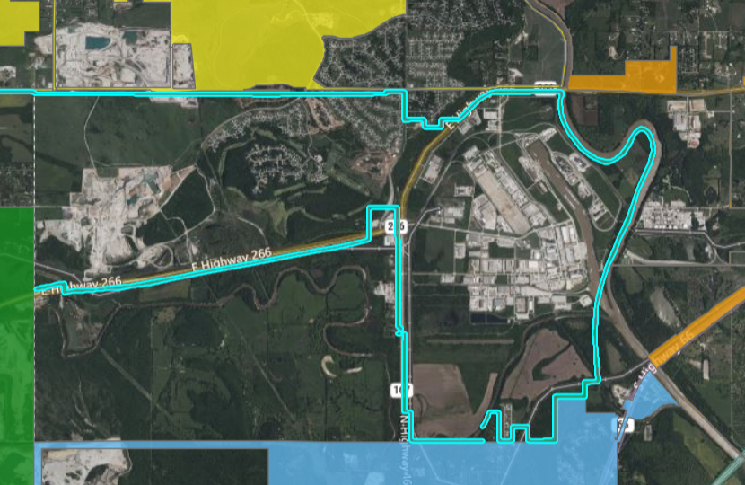 Screenshot from INCOG Tulsa area municipal boundaries interactive map showing Tulsa's fence line (green, outlined in cyan) surrounding the Port of Catoosa. Owasso is yellow, Verdigris is orange, Catoosa is blue. Note that Stone Canyon development is unincorporated but partly within Tulsa's fence line, partly within Owasso's, and partly within neither.
News reports from 1973 and 1974 indicate that the fence line was continuous, but modern maps are confusing. The INCOG interactive map shows a continuous fence line, but as a separate object from the rest of Tulsa, which is different from the way other area cities are depicted. The City of Tulsa's interactive council district map shows the Gilcrease Turnpike fence line near Berryhill, but not the northern fence line; ditto for the OU Center for Spatial Analysis data set. The City of Tulsa redistricting commission's proposed district map from 2021 showed the northern fence line, but with a gap along the southern and southwestern sides of the Port property. Google Maps shows the fence line reaching the Port property but stopping there. Rogers County GIS map shows a continuous fence line.
Wagoner County: On November 8, 2001, the City of Tulsa annexed 13 square miles of land in a fourth county, Wagoner County, most of it formerly in the sparsely populated town of Fair Oaks. There are 22 registered voters in the Wagoner County portion of Tulsa; 7 of them voted in the mayoral election -- 4 for VanNorman, 2 for Keith, 1 for Nichols.
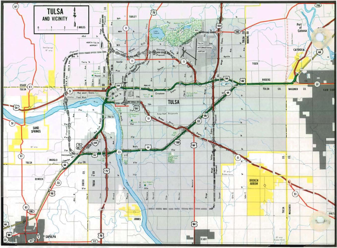 Tulsa metro inset from 1974 Oklahoma state highway map, showing municipal boundaries, including part of Fair Oaks in Wagoner and Rogers Counties. Broken Arrow and Sand Springs fence lines are marked and labeled, but not Tulsa's.
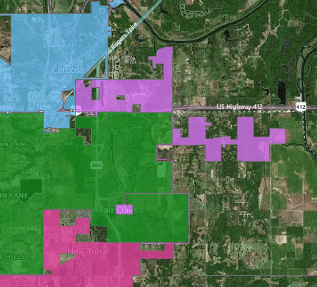 Screenshot from INCOG Tulsa area municipal boundaries interactive map showing Tulsa's Wagoner County area, in green, with the remnant of Fair Oaks in purple.
Turley: A company incorporated in 1906 to develop Turley, and Turley townsite's plat was filed in 1910, but it doesn't appear that the town ever incorporated as a municipality. It was four or five miles away from Tulsa's northern border at the time of its founding. New subdivisions nearby were annexed by Tulsa in the 1950s, and Turley was considered for annexation, but a sanitary sewer bond issue complicated the process. The City of Tulsa would had to have assumed the sewer debt, but would not have been allowed to charge Turley residents more for water and sewer than other Tulsa residents. So despite Tulsa street names and Tulsa water and Tulsa public schools, despite being surrounded by the Tulsa fence line, Turley remains an unincorporated community with the Tulsa County sheriff handling law enforcement, the District 1 County Commissioner responsible for roads, and a volunteer fire department. Turley community is in precincts 720026 and 720326, neither of which has any voters in Tulsa. It's puzzling that the precincts didn't open anyway, because of the fence line, while the similarly situated Rogers County precincts did open.
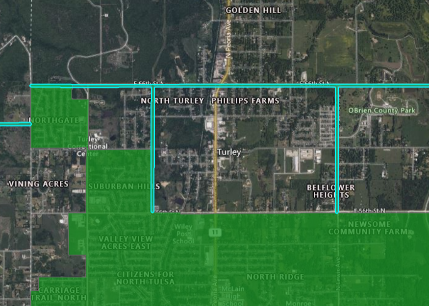 Screenshot from INCOG Tulsa area municipal boundaries interactive map showing Turley, O'Brien Park, and surrounding areas. Note that Suburban Acres and Northgate are within Tulsa's city limits (green), but not Turley or any other neighborhood north of 56th Street North. Tulsa's fence line is green outlined in cyan.
A 1977 state law prevents new municipal incorporations within five miles of large cities (over 200,000) or three miles from small cities and towns, but it was amended in 2004, 2006, and 2007 to allow incorporation of territory "that has historically been identified as a community of people residing in compact form." Berryhill may incorporate under these terms, despite being sandwiched between Tulsa and Sand Springs, and it appears that Turley could as well.