Tulsa Downtown: June 2008 Archives
This week in Urban Tulsa Weekly, I wrote about a tour I was given a few weeks ago of Tulsa's BOk Center arena, scheduled to open this fall. Far from winning me over, the tour convinced me that by foregoing the "iconic" approach to architecture we could have had, for an amount closer to the original budget, an arena that would make a positive addition to downtown's urban fabric.
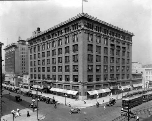
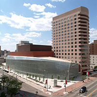
In the column, I mentioned another Cesar Pelli public facility with a curved, "iconic" glass wall. That's the Benjamin and Marian Schuster Performing Arts Center in Dayton, Ohio. The Schuster Center opened in 2003; construction began in 2000. The Rike Building, a handsome seven-story Sullivanesque department store built in 1911, was demolished to make way for the Schuster Center. Before:
After, from about the same angle:
You can see the transformation from good urban form which works well at a distance and up-close at pedestrian scale to a building that is somewhat interesting at a distance but monotonous up close. You would have been able to peek in the display windows of Rike's; the reflective glass on the Schuster Center won't let you see inside.
If you want to take a virtual Google Street View stroll past the Schuster Center, as I suggest in my column, start here and head west on W 2nd St.
There's a nice story on KOTV.com about Michael Sager's 1st Street Lofts, scheduled to be ready for occupancy this fall. Michael gave me a tour during the Blue Dome Arts Festival, and I wrote about some of the interesting ways he is adapting this old building; KOTV's Steve Berg reports on many of the same features, which you can see by clicking the video link at that story.
Doug Loudenback has a post from a month or so ago featuring beautiful vintage postcards of Oklahoma City. Mixed into the pastel tinted images of Prairie Commercial, Sullivanesque, and Art Deco buildings was a fact that should make you gasp:
[The Kingkade Hotel] survived until the 1960s-1970s Urban Renewal era when 447 buildings were destroyed by the Urban Renewal Authority and another 75 more by private owners.
That may be hard to believe, but when you look at a satellite view of OKC, it makes sense. Four blocks cleared for the Myriad arena (Cox Business Center), another four for a massive parking deck, another four for Myriad Gardens, one for Stage Center. I would guess that the two blocks (maybe more) just north of the Cox Business Center were also urban renewal zones. Seven blocks were run through with I-40. I don't know if Doug's number includes Deep Deuce (OKC's version of Greenwood) the area cleared for I-235, or the research park just east of I-235.
Oklahoma City urban renewal was an insane master plan conceived, I'm ashamed to say, by an MIT alumnus, I. M. Pei.
Tulsa's leaders weren't any wiser than Oklahoma City's, just less ambitious, with much of the demolition being accomplished by private, rather than public interests. But Tulsa government did enough damage clearing away buildings that were nicer and more substantial than those you'll find in the Blue Dome District, demolishing nearly all of Greenwood, and blitzing the residential neighborhoods adjacent to the central business district.
Moving west across Cincinnati Ave. from our previous installment, Block 107, we come to Block 106 of Tulsa's original townsite, 2nd to 3rd Street, Boston to Cincinnati Avenue. This block isn't asphalt, but it is radically different than it was as recently as 1970. Part of the Williams Center superblock complex, Boston Avenue was closed north of 3rd Street. The Williams Center Green replaced the street between 2nd and 3rd, along with part of the adjacent blocks. The rest of Block 106 is now occupied by the Performing Arts Center, designed by Minoru Yamasaki, architect of the nearby Bank of Oklahoma Tower and the World Trade Center. While the PAC has an attractive frontage on 3rd, it presents a blank wall along Cincinnati, and a small stage door entrance on 2nd. (How much better it would have been to adapt one of our glorious movie palaces as a performing arts center and to have left this block as it once was.)
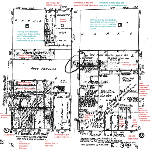
Here's how the block was laid out in the late '50s and early '60s. As before, the image is from Sheet 21 of the Sanborn fire insurance map, last updated in 1962, with my notations in red indicating businesses that were listed in the 1957 Polk City Directory for Tulsa. Click on the thumbnail to pop-up the full 1900 by 1900 image.
The 3rd Street frontage is dominated by the 10-story R. T. Daniel Building and the 13-story Hotel Tulsa; in between was a three-story building that was the original home of Saied Music Co. Note that both skyscrapers had multiple storefronts at street level.
By 1957, we're already beginning to see the erosion of downtown's urban fabric for parking. Between 1939 and 1957, a quarter of the block, and more than two-thirds of the frontage on 2nd Street has been reduced from two or three story buildings to asphalt, leaving the two remaining buildings on 2nd rather forlorn.
The population in 1960 was 21 (Census Tract 25, Census Block 57).
Now for some photos -- I will add more as I find them. There are so many photos of the Hotel Tulsa that I will put them in a separate entry at a later time, but here is a good shot of the Hotel Tulsa that shows some of the rest of the block:
(Photos from the Beryl Ford Collection/Rotary Club of Tulsa, Tulsa City-County Library and Tulsa Historical Society.)
More photos after the jump.


